Canada’s Green Transport Cities - Methodology and sources
By Kijiji Autos
Methodology
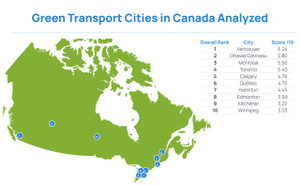
In order to determine which Canadian cities had the Greenest Transportation, we looked at a variety of metrics to create a ranking. Taking the 10 highest populated cities, we found data points associated with sustainability and travel to rank each city against one another.
When creating a ranking system, we used a formula which scores each metric. The formula gives metrics a score between 1 and 10. For some data points, i.e. the higher the number of electric charging points, the higher the score.
For some data points, such as the price of a bus ticket, the higher the bus fare the lower the score. This formula is carried out across all data columns. In some cases where a numerical figure was not possible i.e if the city has an electric bike share program, yes = 1 and 0 = No. To produce the final rankings, an average score is calculated across the data columns per location.
Sources
Data collected 20-23/09/2021
https://worldpopulationreview.com/countries/cities/canada
Notes:
Population, only cities have been used, not provinces or districts
No. of electric cars on the road
- Calgary
- Hamilton
- Surrey
- Halifax
- Edmonton
- Windsor
- Toronto
- Mississauga
- Vancouver
- Brampton
- Oshawa, Montreal, Gatineau, Ottawa, Winnipeg, Victoria
- London
- Kelowna
Notes:
- Mississauga electric vehicles: data from Toronto, its nearest city, has been used.
- Vancouver electric vehicles: number of vehicle insurance policies by electric models used for 2020.
- Brampton electric vehicles: data from Toronto, it's nearest city, has been used.
- For these cities; Oshawa, Montreal, Gatineau, Ottawa, Winnipeg and Victoria, data has been taken from Q1 of 2021 for newly registered electric cars.
- Laval electric vehicles: data taken from Montreal, it's nearest city.
- Kelowna electric vehicles: data taken from the number of consumers who have opted-in to the high-occupancy vehicle lanes which are available to those who drive electric vehicles.
- Markham electric vehicles: data from Toronto, it's nearest city, has been used.
No. of cycle routes
https://www.bikemap.net/en/l/6251999/
Bike rental programs
Source:
- Toronto
- Montreal
- Vancouver
- Hamilton
- Ottawa
- Gatineau
- Laval
- Calgary
- Windsor
- Edmonton
- Mississauga
- Brampton
- Markham
- Oshawa
- Kelowna
- Winnipeg
Notes:
- Markham bike rental program: information from Toronto, it's nearest city, has been used.
- Oshawa bike rental program: information from Toronto, it’s nearest city has been used.
Number of electrical charging points
https://chargehub.com/en/countries/canada/
Public transport methods
- Ottawa
- Edmonton
- Mississauga
- Winnipeg
- Vancouver
- Hamilton
- Brampton
- Surrey
- Laval
- Halifax
- London
- Kelowna
- Victoria
- Windsor
- Markham
- Montreal
- Toronto
- Calgary
- Gatineau
- Oshawa
Notes:
Gatineau price fares: uses its nearest city Ottawa data.
Bus ticket costs
- London
- Winnipeg
- Hamilton
- Brampton
- Halifax
- Kelowna
- Victoria
- Vancouver
- Montreal
- Laval
- Toronto
- Mississauga
- Ottawa
- Calgary
- Gatineau
- Oshawa
- Hamilton
- Surrey
- Edmonton
- Windsor
- Markham
E-scooter programs
- Vancouver
- Montreal
- Victoria
- Laval
- Toronto
- Mississauga
- Calgary, Edmonton, Ottawa, Windsor
- Gatineau
- Hamilton
- Surrey
- Markham
- Brampton
- Halifax
- Winnipeg
- London
- Kelowna
Congestion levels
https://www.tomtom.com/en_gb/traffic-index/
Notes:
- Mississauga, Brampton, Surrey, Laval, Victoria, Markham, Oshawa, Gatineau and Kelowna: the closest city with available data was used.
- For Windsor, Detroit has been used as the closest city.
Air pollution levels
Source:
Notes:
- Each city was searched for to produce its own pollution data.
- Pollution: Markham data represented by Toronto due to lack of source.
Airports
Note:
Each city was Googled to find the nearest airport.
Easily find your next ride on Kijiji Autos
Search now